Geomatics solutions in Ottawa
Need reliable geomatics solutions services in Ottawa? G | O Geomatics delivers precise, cost-effective solutions with 30+ years of expertise.
“Our team has the grit and the skill to tackle any problem—because we invest in our clients’ success.”
About
G | O Geomatics
At G | O Geomatics, precision and innovation drive every project. Based in Ottawa since 2025, our team leverages over 30 years of combined experience to turn complex challenges into accurate, actionable solutions. We integrate advanced technology with a steadfast commitment to quality and safety, ensuring every project—be it drone mapping, construction layout, or utility detection—is executed flawlessly. Trust us to deliver excellence, one precise measurement at a time.
Why Choose G | O Geomatics?
With over 30 years of expertise, we are committed to safety, quality, and precision in every project. Using cutting-edge technology and deep industry knowledge, we deliver tailored geomatics solutions across Ottawa and surrounding areas. Clear communication and reliable results ensure a seamless experience from start to finish.
Proven Expertise & Experience
With over 30 years in the industry, we understand the unique challenges of large-scale projects. Our seasoned team delivers strategic, precision-driven solutions that ensure your success.
Cutting-Edge Technology & Innovation
We leverage state-of-the-art geomatics tools—from 3D scanning to advanced drone mapping, HP Site Print, Stream DP —to provide accurate, actionable data. Our innovative approach gives you a competitive edge.
Tailored Solutions & Transparent Communication
Every project is unique. We customize our services to your needs and maintain clear, direct communication throughout, ensuring seamless execution and risk-free results.
Our Comprehensive Services
At G/O Geomatics, we offer a complete range of geomatics services to meet all your construction and surveying needs in Ottawa and its surrounding areas. Our expertise spans the following areas :

Construction Surveying
Precise construction layouts and as-built/topographical surveys to ensure your projects start on the right foot.

3D Scanning and Modeling
High-resolution scans and advanced CAD integration for detailed site mapping and design accuracy.

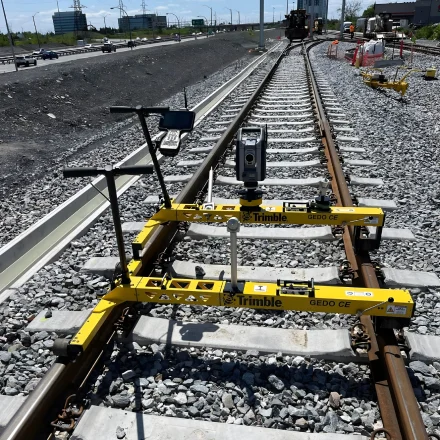
Rail Geometry Survey
Rail geometry refers to the design and alignment of the components that make up the railway track, ensuring that trains can run smoothly, safely, and efficiently.

Underground Utility Detection
Reliable identification of subsurface utilities to safeguard your project and prevent costly mishaps.

Quality Assurance & Monitoring
Rigorous quality control and continuous site monitoring to guarantee exceptional results throughout your project.

Machine control
Our machine control service integrates advanced GPS and sensor technology to automate heavy machinery operations.

Advanced Drone Photogrammetry
Innovative aerial data collection and precise measurement solutions that deliver unparalleled accuracy.

Metrology Services
Innovative aerial data collection and precise measurement solutions that deliver unparalleled accuracy.
Our projects
Discover our portfolio—where passion meets precision. Our projects showcase meticulous planning, flawless execution, and results that exceed expectations, delivering lasting value.


Your Questions, Our Answers!
What services do you offer?
We provide a full range of geomatics services, including construction layout, 3D scanning, underground utility detection, quality control and monitoring, machine control, and advanced drone services & metrology—all tailored for large-scale construction projects.
How much experience does your team have?
Our team brings over 30 years of combined expertise, ensuring precision and reliability in every project we undertake.
Which areas do you serve?
We primarily serve Ottawa and its surrounding areas, offering our services to both local contractors and large-scale construction companies.
What kind of technology do you use?
We leverage cutting-edge equipment including state-of-the-art 3D scanners, advanced drone systems, GPS, laser-guided machinery and robotic total station to deliver highly accurate and efficient results.
How do you ensure the quality and accuracy of your work?
Our process is driven by rigorous quality control, transparent communication, and continuous monitoring. We combine advanced technology with proven expertise to exceed industry standards.
Do you offer free estimates?
Yes, we provide free, no-obligation estimates. Simply contact us to discuss your project requirements.
Are you licensed and insured?
Absolutely. We are fully licensed and insured, giving you peace of mind and ensuring compliance with all industry regulations.
How do you integrate with existing project teams?
We work closely with your team, providing clear communication and a collaborative approach to seamlessly integrate our services into your project workflow.
What industries do you serve?
Our expertise spans construction, civil engineering, and infrastructure projects, making us a trusted partner for complex, large-scale ventures.
How can I get in touch?
Reach out to us via our contact page, email at info@g-ogeomatics.com, or call us at (613) 221-9915 to discuss your project needs.
